 Back to Contents
Wallace J. Nichols (jnichols@ag.arizona.edu), of the University of Arizona, is involved in a joint project of the University of Arizona and Centro Regional de Investigaciones Pesqueras--Ensenada, Baja California. The project involved tagging a loggerhead (Adelita, tag 7667) and tracking her as she migrated across the Pacific Ocean.
Part of the project was a mailing list for those interested in receiving the latest location information. This list now carries information of the project's newest tagged turtles. You can join the mailing list by writing to jnichols@ag.arizona.edu.
Adelita was released on August 10, 1996, just off a small town in Mexico called Santa Rosaliita (the red mark on the Baja Peninsula) and started immediately across the Pacific. Adelita is an important loggerhead because a recent loggerhead tag return drew attention to the theory that loggerhead turtles foraging off the west coast of Mexico and California actually nest at beaches in Japan. Adelita has shown beyond doubt that this theory is correct.
Note 1: If you are using this data in a classroom at a university, high school, middle or elementary school, or if you're sharing it with your kids or friends, could you please drop a note to Lynn Jimenez (laj@fuse.net). The CCF would like to get an idea about the reach of this sort of project.
Note 2: On February 18, 1997, the Web edition of The Arizona Daily Star carried a terrific story about Adelita, written by Raya Tahan. This story mentions a program for schools that want to raise funds and sponsor more electronic tags. Wallace J. Nichols has announced that the project now has a source of matching funds, so if you or your school is interested, write to him at: jnichols@ag.arizona.edu.
On October 4, 1997, we posted what we expected to be the last positions we will get for Adelita. It had been over a year and her battery was past its expected life. These positions were recorded on the 12th and 13th of August, almost exactly a year after her release.
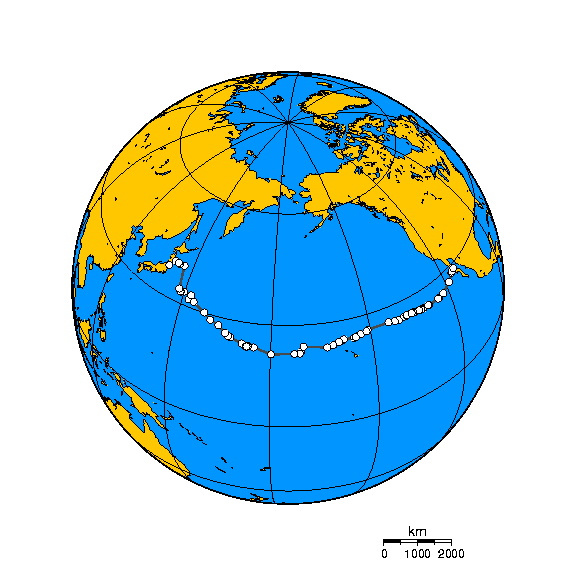
All of the last positions were close together and not far from the last position in the previous set we received. Also, some of them had the highest accuracy class. Adelita therefore demonstrated conclusively and spectacularly that loggerheads migrate across the Pacific. Here's an orthographic projection, courtesy of Wallace J. Nichols, showing Adelita's complete track:

At the 18th Annual Sea Turtle Symposium in Mazatlan, however, J revealed that another set of points had been received. Tragically, these points were not consistent with Adelita swimming around near the coast of Japan. After two weeks without receiving signals, a set was transmitted that indicated progress significantly more rapid than her highest rate of swimming, and on a course straight to the nearest port, Sendai.
Of course, it is impossible to be sure what actually happened, but the most likely possibility is that Adelita made an amazing (and for sea turtle research, historic) 12,000 km journey all the way across the Pacific, only to be trapped by a net or longline and drowned.
J has said that he would prefer not to make a big issue out of her death, and rightly so. Adelita, precious though she was, was only one turtle. While the seas around Japan are full of longlines and nets, there is not enough data to determine whether this is a serious problem for sea turtles. Clearly, more study is needed.
I've been in Japan for the past several weeks, visiting nesting beaches in the south, some schools on yakushima and one goal being to visit the location where Adelita made landfall. The 'expedition' ended up being more than a simple effort. Trains, Pouring rain, a faulty GPS unit, help from a Phillipeano coal tanker (gave us our position), jelly donuts from some friendly Jehova's Witnesses, and finally when we had walked along the coast for about 5 hours in the rain (the GPS finally kicked in) we arrived in the squid fishing village where we think Adelita arrived in Japan. Trying desperately to explain with sign langauge, drawings, a few japanese words learned along the way and a note explaining our search written in Japanese by a friend we were not getting very far. After coming all this way I wasn't going to let my lack of Japanese language ability stop us.
I asked "Internet?"
"Hai" (yes).
The fisheries director enthusiastically pulled out a laptop and dialed in to a local server, opened up MS Explorer and handed it to me. I typed in the most familiar URL I know: www.turtles.org and directed the browser to the Adelita page.
Pretty soon a small crowd had gathered in the office around the screen and we were looking at several of Adelita's maps, photos, poems, etc. A connection was made and he understood what we were looking for. With the help of a dictionary he explained that this year very few turtles were caught, but in 1997 when Adelita was in the area, more turtles were caught--perhaps one of them was Adelita. He said he would investigate more with the group of fishermen working out of the port (Isohama) over the next few days--they weren't currently fishing due to the terrible weather. We exchanged phone numbers and email. Anyhow, we'll see what more we can learn over the next few weeks. Now we know a little bit more about Adelita's journey.
Thanks for your help via Turtle Trax.
Barbara Garrison, a teacher who followed Adelita's progress across the Pacific, wrote this poem early in Adelita's swim, before her fate was known. With hindsight, it has become a poignant eulogy.
Adelita sleeps...
do you ever find yourself
thinking of her
in the middle of the day?
sister of mercy
adrift in the world
her carapace around her
like a habit
following the liturgy of longitude
like the Stations of the Cross
the draw string of dream
gathering with each dive
a sea shadow
cradled in the arms
of the great Turtle Mother
the Virgin of Cobre guiding
through the dangerous sea
the black sand memory
of her natal beach
ringing her course
in peals of instinct
cartographer
explorer
world traveler
Adelita sleeps
a Shinto priestess
leads the way
a goddess path
from Mexico
to the arribada
on a distant
Kyushu shore
--Barbara Garrison
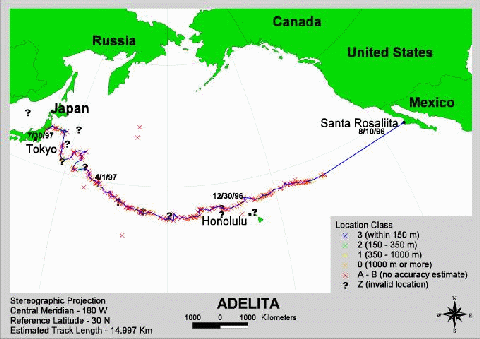
Here's the last plot that Michael has sent, reflecting positions up to July 31, 1997. This graphic uses colour-coded marks indicating the location class (accuracy) for each point plotted. Please keep in mind that the number shown here for the length of Adelita's entire track should not be taken as an attempt to measure her path with any accuracy. It is provided to give you a rough idea only.

Adelita's entire track up to July 31, 1997, approximately 14,997 km (113K JPEG)
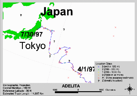
As you can see, Adelita had arrived in Japan. This close-up of her last positions shows you what we mean. Note, however, the colours of the points. The ones that put her closest do not have a high accuracy class associated with them. On the other hand, as we mentioned above, some of the positions in her last set (not included in this graphic) were of the highest accuracy class and showed her right at the Japanese coast.

Close-up of Adelita's latest position reports (37K JPEG)
We've taken the data we received and used it to plot Adelita's course on a map generated by the Xerox PARC Map Viewer on the Worldwide Web. Our first map includes all her reported positions up to and including December 31, 1996. Here's how Adelita's track for 1996 looked:
Each '+' on the plot represents a recorded position. Because this map does not include the time and date of each plot, it isn't possible to use it to tell how long it took Adelita to get from one point to the next. In general, the data points are about a day apart, but there are several large gaps. There are also several days for which we have more than one report. You can get a better idea of how close the data points are to each other by visiting the Xerox PARC site and using the Map Viewer to zoom in on Adelita's position.
As you can see from the previous map, Adelita was just north of Hawaii at New Year's. The following map shows positions at least half a degree of longitude apart that were reported for her from January 1 onwards. As of August 13, her 1997 track looked like this:
Again, you can examine this plot more closely by visiting the Xerox PARC Map Viewer and using the zoom feature.
As wonderful as the Xerox PARC Viewer is, it does have limits. One of them is that you can only send it 100 points to plot, so we have to remove some. Unfortunately, the way in which we reduced the number of points in the previous map makes it harder to see lateral (north-south) movement, so we've used two more maps.
This map plots the first 100 positions reported for Adelita after January 1, 1997. As always, you can zoom in on these positions by using the Xerox PARC Map Viewer.
Finally, this map shows the last 100 reported positions for Adelita. The first position on this map was recorded on April 2, 1997. By now, you know the Map Viewer drill.
For those of you who use the Xerox PARC Map Viewer to zoom in on Adelita's position, we have some comments about the accuracy of the data from Wallace J. He notes that each position report is accompanied by a "location class", which basically tells how accurate the data is. Classes include:
If Adelita appears to be jumping around the Pacific unrealistically, remember that some positions are reported with a much higher margin of error than others.
Turtle Trax extends a hearty mahalo to Wallace J. Nichols for providing this fascinating information. For more information about what J is up to, visit Baja Tortugas!.